Hiking Jotunheimen “home of the giants” with a tent
Jotunheimen, known as the ‘Home of the Giants,’ stands as Norway’s premier national park, yet it remains surprisingly uncrowded. We’ve crafted a week-long itinerary for self-sufficient hikers eager to explore Jotunheimen’s most captivating sights.
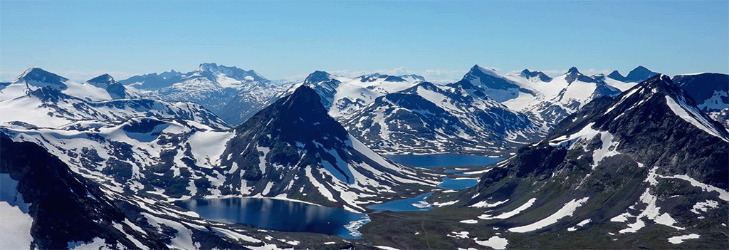
Imagine a world of emerald lakes nestled in deep valleys, vibrant mountain streams cutting through the landscape, expansive glaciers, and the loftiest peaks in Norway, including the awe-inspiring ridge that crowns Scandinavia. Jotunheimen National Park is a hiker’s paradise, offering a blend of Norway’s most stunning landscapes and breathtaking panoramas.
Faced with the challenge of experiencing the essence of Jotunheimen, my friend Jan and I deliberated over which trails to embark upon. Given our one-week timeframe, we had to make a tough choice: explore the national park’s eastern realm, home to the iconic Besseggen Ridge, or venture west towards Utladalen, home to Norway’s deepest valley and the towering Vettisfossen waterfall, which plummets 273 meters. The vast wilderness of Jotunheimen, sprawling four times the size of Amsterdam, meant covering both areas was beyond our reach with our human pace.
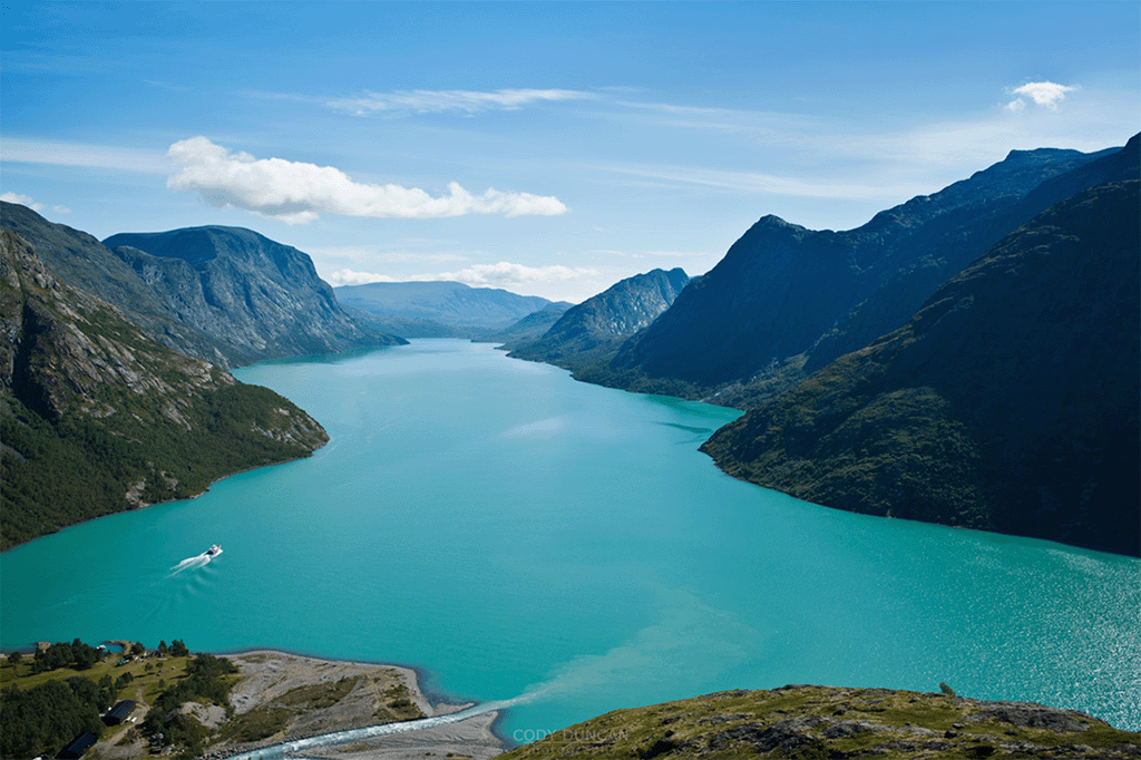
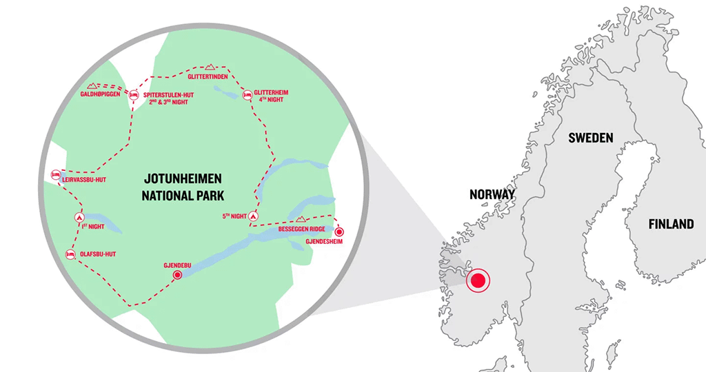
We decided on a classic journey through Jotunheimen’s eastern territories, the bustling core of the national park. Here lies the mesmerizing Lake Gjende, known for its ferry connections, surrounded by Norway’s tallest mountains, Galdhøpiggen and Glittertind, inviting adventurers into the heart of giant territory.
Essential Guide to Trekking in Jotunheimen
Getting There: During the summer months, express buses operate from Oslo directly to Gjendesheim, continuing towards Lom and Leirvassbu. To ensure a spot on the Lake Gjende ferry, it’s advisable to book your ticket online ahead of your journey.
Right to Roam: In Norway, the principle of Allemannsretten grants everyone the freedom to wild camp and stay overnight in natural and wilderness areas. This right applies as long as the area is not cultivated or near habitation—campers should maintain a distance of at least 150 meters from inhabited buildings. In Jotunheimen, and particularly around Spiterstulen, the regulations vary slightly. Campers are required to either pay for a campsite or pitch their tent at a greater distance from the site. Note that campfires are prohibited from April 15 to September 15, and it’s imperative to leave no trace by taking all rubbish with you.
Choosing a Map: For navigating the trails of Jotunheimen, the most comprehensive and detailed map is produced by the Swedish publisher Calazo, at a scale of 1:50,000. The map includes English legends, making it accessible for international hikers. While available at the Gjendesheim ferry terminal kiosk, purchasing one online in advance from a German retailer may be more convenient for some trekkers.
A Week of Wilderness: Trekking in Jotunheimen with a Tent
Discover the pinnacle of Norwegian hiking in the accessible yet serene Jotunheimen National Park. While it’s a popular summer destination, the vastness of the park means you can still find solitude, particularly on the rainier days that are not uncommon here. This solitude is more profound for those camping in tents, occasionally seeking the warmth of the park’s numerous huts for a brief respite. For the seasoned, weather-hardened trekkers, Jotunheimen presents an almost mystical experience, akin to a high-altitude expedition, with the added comfort of mountain huts along the way for a welcoming break with a coffee or beer in hand.
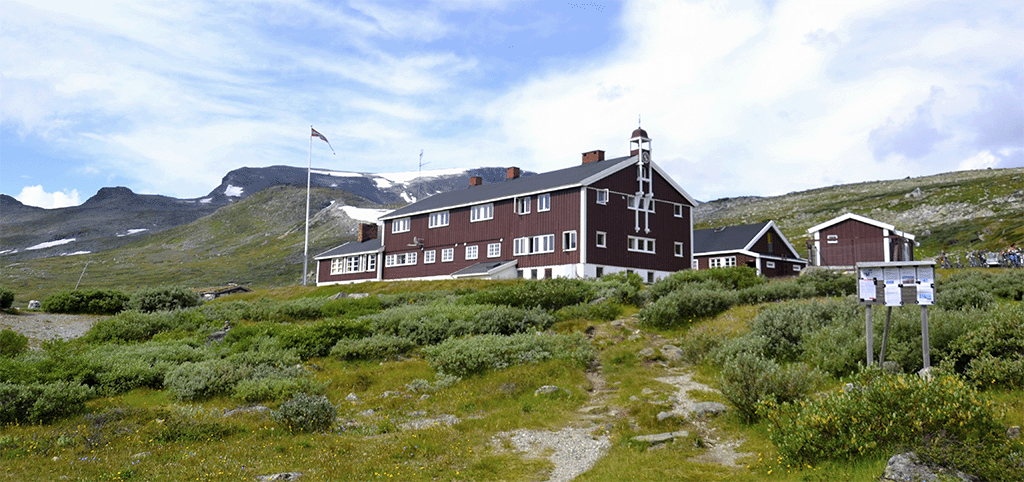
The Gjendesheim Mountain Lodge, perched by the stunning Lake Gjende, serves as an ideal kickoff point for a week-long circular trek. Accessible by bus, with parking available for those driving, the lodge is where your adventure begins. Before setting out, one critical decision awaits: tackling the iconic Besseggen Ridge at the journey’s outset or saving it as a grand finale. We suggest opting for the latter; completing your trek with the ridge allows you to acclimate and prepare for its steep, challenging terrain. This approach not only ensures a safer journey with a heavy pack but also sets the stage for a dramatic culmination of your trekking adventure.
Trekking Jotunheimen Stage 1: Venturing from Gjende to the Wilderness
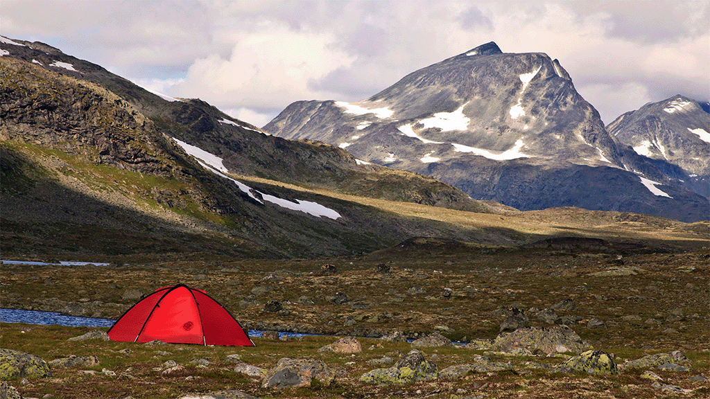
Our adventure begins with the scenic drive from Oslo to Gjende, where even the journey itself unveils the breathtaking landscapes Norway has to offer. Settling in for the night, we find a cozy spot near the Gjendesheim hiker’s car park to pitch our tent beside a river, instantly immersing ourselves in the great outdoors despite having barely ventured from our starting point.
With the Besseggen Ridge reserved for our trek’s climax, we embark early by ferry, plunging deeper into Jotunheimen’s heart. Departing from the DNT Gjendesheim lodge at 07:45, the ferry voyage across the lake is a spectacle in itself, delivering us to the remote Gjendebu hut.
Our path then takes us through Veslådalen, aiming for Olavsbu as our next waypoint, with plans to camp nearby. The journey is marked by a light drizzle that does little to dampen our spirits or our outdoor breakfast of porridge.
Leaving the tree line, we enter the stark beauty of the Scandinavian highlands, a landscape of stone, grass, and snow, uniquely mesmerizing. The tranquility is palpable, especially in the moments when the wind ceases, offering us the serene isolation we sought on this Norwegian trek.
Traversing Rauddalen, the day’s light remains constant, casting a timeless glow over our journey. Our first glimpse of Olavsbu, a welcoming self-service hut, comes after hours of trekking. Yet, our adventure pushes us further, over the Rauddalsbandet pass and through snowfields to a secluded valley beyond, where we set up camp just as the rain begins in earnest.
Here, in the solitude of the high mountains, we’re truly alone, pioneers in a vast, untamed wilderness, fulfilling our quest for the untouched beauty of Norway.
Stage 2: Journey to Spiterstulen via Leirvassbu
Our sights are set on Spiterstulen, the prime gateway for climbing Galdhøpiggen, with a challenging 20-plus kilometers ahead of us. But it’s not the distance alone that tests us; it’s the terrain beneath our boots. Navigating rocky paths and scree fields demands resilience and robust, yet nimble, hiking footwear.
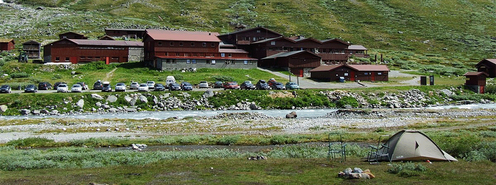
By the time late afternoon rolls around, we find sanctuary at Leirvassbu, a welcoming lodge where we whip up an early dinner on our gas stove.
The trek towards Spiterstulen proves to be equally demanding, leaving us to ponder if the terrain will relent or if the pace will remain as grueling. Yet, as the clouds part, our spirits lift with the sun’s rays warming our path through the picturesque Visdalen, beside a briskly flowing river. The day heats up, encouraging us to roll up our sleeves, transforming our rigorous hike into a delightful saunter.
At Spiterstulen, campers are invited to settle across the river for a fee of 110 kroner (about $10/£8) per night, which includes access to the facilities. Those preferring to wild camp must stay a minimum of one kilometer away from the privately owned lodges. As a chilly breeze sweeps through the valley, the lure of the warm common room is irresistible, leading us to opt for the convenience of on-site camping.
Stage 3: Tackling Galdhøpiggen’s Winter Wonderland
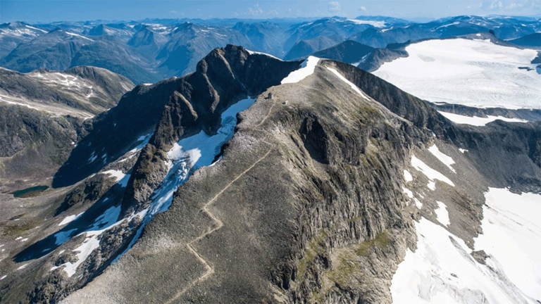
Scaling Galdhøpiggen marks a pinnacle moment of our adventure, presenting the ultimate high in Norwegian trekking.
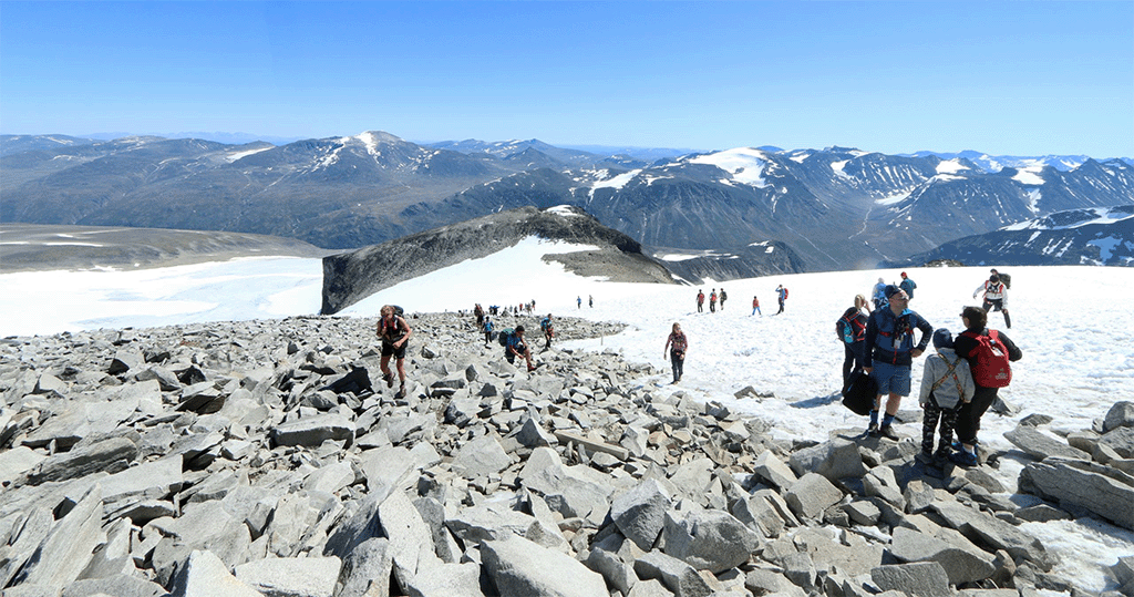
The journey to its 2,469-meter summit offers two main paths. Opting for the route from the north via Juvasshytta involves crossing a glacier, necessitating the use of ropes or the guidance of a mountain expert. Alternatively, the path from Spiterstulen ascends a craggy ridge, bypassing crevasse risks. For this climb, we lighten our load, carrying only essential gear in our daypacks, a welcomed reprieve from the weight of our full equipment.
The climb begins with a steep zigzag trail, affording us expansive views of the terrain below. Eventually, the defined path gives way, leaving only sporadic red markers as our guide. The weather shifts dramatically; thick fog rolls in, reducing visibility, followed by a soft snowfall that quickly deepens around our boots.
Navigating the east ridge, the ascent presents us with deceptive false peaks before revealing the true summit. To our side, a sheer cliff plummets to the glacier below, obscured by the dense mist.
After a challenging three-hour trek, a lone figure emerges from the whiteout, retreating from the summit. He had lost the trail. Not long after, we find ourselves in a vast, indistinct snowfield, the path swallowed by the fog. Persevering across the slope, our spirits lift when we stumble upon a prominently marked boulder, reassuring us we’re on the correct course towards the summit.
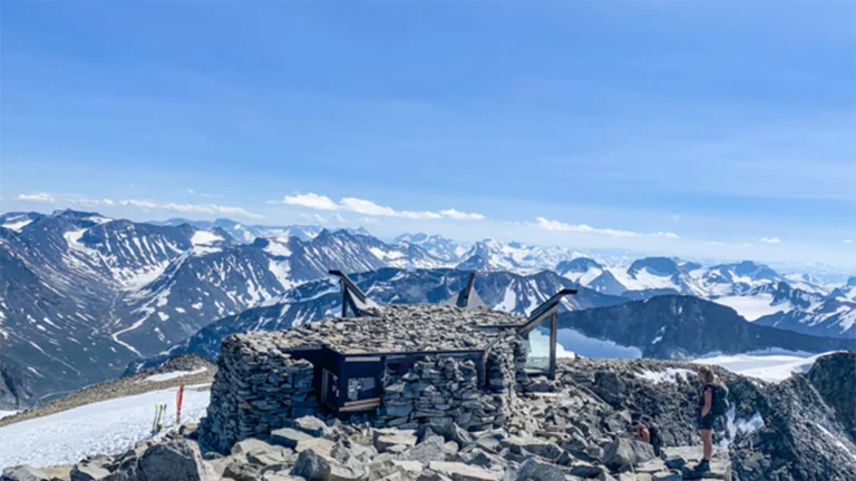
Suddenly, the summit emerges as if by magic. A quaint stone shelter materializes from the fog, its presence almost mythical in this desolate, unwelcoming expanse. Crossing the threshold, we step into a cozy, timber-lined refuge, complete with tables and a modest kiosk, manned by a warm-hearted Norwegian lady. Today, she swaps her mountain guide role to welcome weary travelers. The only drawback? The absence of electricity means no chance of a warming cup of tea. Yet, the shelter’s inviting atmosphere more than compensates.
It turns out, inclement weather hardly deters the Norwegian spirit for mountain adventures. Descending, we encounter a steady stream of hikers, shattering any notion of our journey being a solitary venture into the wild. Meeting two men in shorts, accompanied by a dog, quickly dispels any remaining thoughts of our trek being an extreme arctic exploration.
Stage 4: The Ascent of Glittertind
Our paths diverge here. I set my sights on conquering Glittertind, standing tall at 2,464 meters, en route to the Glitterheim lodge, while my partner Jan opts for the valley path skirting the base of Norway’s second loftiest peak. This alternative offers a viable route for those days when the mountain’s mood is soured by inclement weather or treacherous snow.
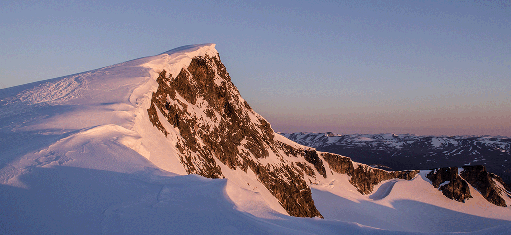
Today, my journey is shrouded in mist, devoid of vistas, yet mercifully free from rain or snowfall. Approaching the mountain, a serene encounter with some reindeer lifts my spirits. The trail soon presents itself, a direct ascent up the steep incline. With a 15-kilo burden, my progress is labored, each step a testament to endurance, my heart pounding through the thin mountain air. As elevation gains, the slope becomes more forgiving. The mist envelops me in a silent, rocky world. Nearing the peak, patches of snow blanket the ground, the path remains clear but demands respect; a snow cornice lurks dangerously close to the trail’s edge, a reminder to tread carefully.
Reaching the summit grants me solitude, momentarily. This tranquility is soon shared with a Norwegian couple who arrive, exuding a calmness and joy seemingly born from a lifetime of navigating these wild, wintry landscapes.
Descent from Glittertind: Navigational Dilemmas
Descent proves challenging as the markings elude me, and I find myself off course. A chance encounter with a fellow hiker heading in the opposite direction offers guidance—explaining an alternative descent directly over the expansive snowfield, a route sometimes enjoyed as an impromptu toboggan run. Opting for caution, I choose to adhere to the established trail.
The return journey to Glitterheimen lacks the earlier mountainous drama, the landscape’s monotony prevailing. As I descend, I rendezvous with Jan, contentedly sipping coffee in the welcoming warmth of the DNT hut.
Camping regulations remain consistent; wild camping near the hut is forbidden. We opt for the official camping option, costing 100 kroner per person per night (approximately $9/£7). The perks are undeniable: access to refreshing beverages and a cozy indoor space to unwind.
Stage 5: A Nordic Wilderness Adventure Unveiled
The penultimate stage of our trek leads us from Glitterheimen to the iconic Besseggen Ridge, encapsulating the quintessential essence of the Scandinavian wilderness.
Early on, we encounter a picturesque hanging bridge spanning a turbulent river—a prelude to the scenic wonders ahead. The trail gradually ascends, ushering us into the embrace of the next valley. A serene lunch break beside a briskly flowing stream offers panoramic views of the jade and turquoise waters of Russvatnet lake. Descending to the lake’s shore, we chance upon a flat, sandy bay, compelling us to take a bracing dip in the invigoratingly cold water—refreshing but shiver-inducing!
Having donned warm attire, we proceed along the lake’s edge and ascend the valley’s summit to find an ideal spot to set up our tents. Leaving our backpacks at the hill’s base, we ascend the northern slopes of Besseggen, chasing the evening light. Peering over the ridge’s other side, we glimpse Memurubu by Lake Gjende, a starting point for day trippers.
While briefly regretting our decision to camp in the small valley rather than atop the ridge, we resolve to return before dawn the next morning. This choice proves prescient.
Stage 6: Conquering the Renowned Besseggen Ridge
The early rise at 04:30 proves to be a wise decision. Armed with our packs, we return to the ridgeline before dawn, anticipating a breathtaking sunrise that unveils a panoramic spectacle of the Jotunheimen mountains—a perfect setting for brewing morning coffee on our trusty stove.
While the initially amiable weather hints at a fleeting stay, the skies gradually overcast, and clouds encroach upon the horizon. Encountering informational signs along the way, we learn that hikers who have expended a certain timeframe from Memurubu to this juncture are advised to retrace their steps—a testament to the underestimated length of this popular trek.
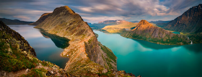
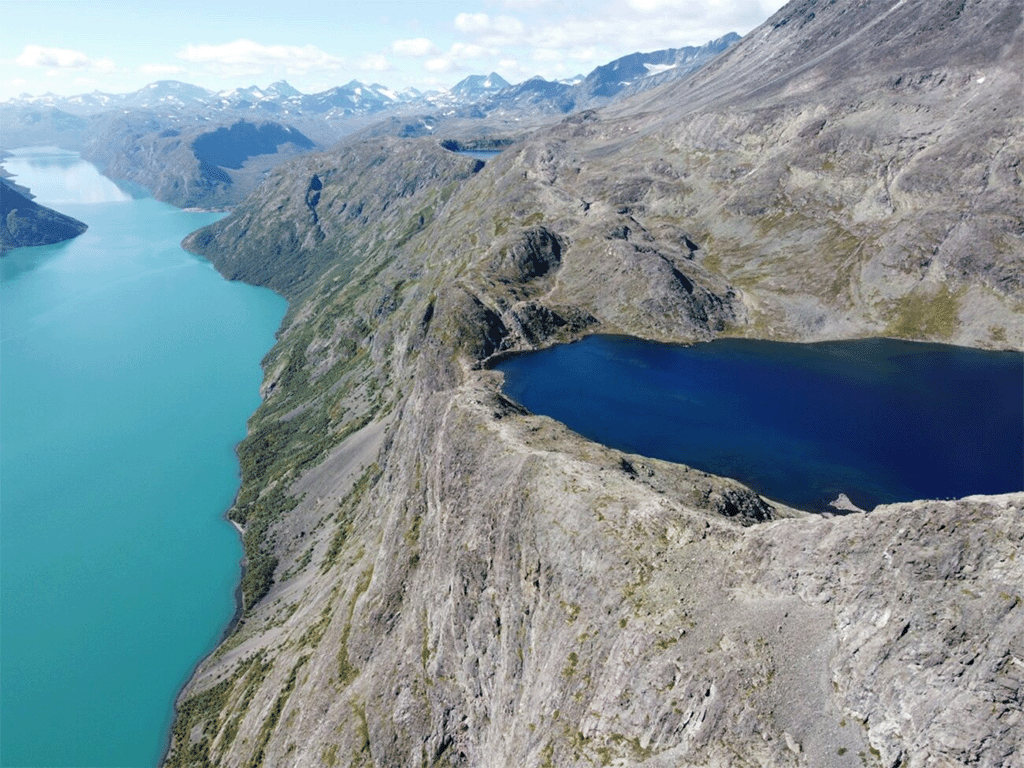
Pressing forward, we traverse past quaint mountain lakes, building anticipation for the pinnacle of our journey. To one side, the southern fringe of Lake Bessvatnet unfolds, while on the other, a precipitous cliff plummets hundreds of meters from the ridgeline to Lake Gjende. Here, one literally walks on the edge—a test for those with a head for heights.
Culminating in Splendor: The Pinnacle of Our Journey
Ascending to the apex of our circular sojourn, we encounter the most challenging and visually captivating segment of the trail. The ridge unfolds, guiding us over facile, blocky scrambling towards a rocky tower, featuring stretches of notably exposed terrain. As rain commences, the stones become slick underfoot, urging us to seek a secure vantage point to fully savor the panoramic vista.
Upon a strategic perch, we pivot to gaze backward—Lake Gjende adorning the left and Lake Bessvatnet gracing the right, demarcated by the slender, serrated Besseggen ridge. A staggering 400-meter disparity in altitude between the two lakes adds to the dramatic spectacle. Soon, veiling clouds obscure the landscape, casting a mystic shroud over the scenery. In a mere two hours, we return to our vehicle, filled with gratitude for the multifaceted wonders that Jotunheimen has graciously unveiled before us.