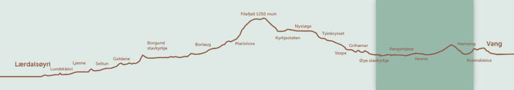
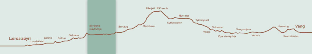
Kings Road hiking route
Entire trip
| Time | Difficulty | Distance | Suitable for |
| 3 – 6 days | Medium | 100 km | Everybody |
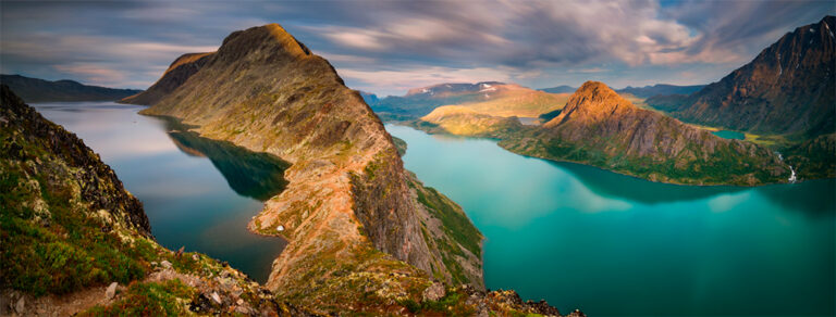
Embark on a 100 km journey that starts from the remote villages in the upper Valdres region, traverses the majestic Filefjell mountain, and descends into the stunning landscapes at the heart of Sognefjorden.
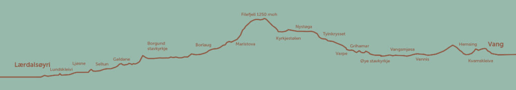
The trek along Kongevegen across Filefjell is divided into 12 distinct legs (see below). Depending on your pace and interest in various sights along the route, the walk can span 3 to 6 days.
Additionally, there are four circular routes rich in cultural and historical significance. Notable examples include the Galdane–Seltunåsen and Vindhella–Sverrestigen trails.
In 2017, Kongevegen across Filefjell was honored with the Europa Nostra Award, the European Union’s highest accolade for cultural heritage. The route was also recognized as one of the Grand Prix laureates and secured second place in a public vote. Previously, in 2015, the road received the “Vakre Vegars Pris” or the Beautiful Roads Award, further cementing its status as a path of both beauty and historical importance.
Leg 1 – Kvamskleive
| Time | Difficulty | Distance | Suitable for |
| 1 – 1,5 hours | Easy | 4,7 km | Everybody |
If you commence your journey from the east, Kvamskleiva is the first leg over Filefjell.
This original 4.7 km segment primarily consists of a grassy track, with the initial 300 meters from Søndrol being on gravel. Unveiled in 1808, this stretch replaced the earlier Kongevegen route, which traversed the opposite side of Lake Vangsmjøsa—from Høre across Hensåsen and Remmisåsen, then descending to Lerhol, where a ferry crossing to Hella was available.
Kvamskleiva, characterized by its steep ascent, posed significant dangers, especially during winter, climbing 150 of its 250 meters in the initial kilometers. In 1833, Englishman John Barrow, who traversed the route, described the scene below Kvamskleiva as an “abyss” and noted the absence of measures to prevent vehicles from skidding off the road. Subsequently, robust retaining walls were added, ensuring safety. As you approach the summit, enjoy spectacular views of the Vang villages, Lake Vangsmjøsa, and the mountains—a perfect spot for a break. At this point, remnants of the old walls can be observed, and you can glimpse the current E16 far below. Rest assured, the road has been reinforced and is secure for use.
Continuing upward, the road levels out, guiding you through the picturesque Grønolen area. The journey persists through an enchanting blend of forest and open cultural landscape until you reach Kvam farm, the historic residence of the district sheriff. Look for signs directing you to the old, meticulously restored farm, which may occasionally be open for food and guided tours.
Leg 2 – Vennisvegen
| Time | Difficulty | Distance | Suitable for |
| 5 hours | Easy | 18 km | Everybody |
Vennisvegen winds its way through the villages on the northern side of Lake Vangsmjøse, offering a journey through a diverse cultural landscape.
The majority of the path is paved, tracing along the opposite side of Vangsmjøse from the E16. This route also serves as the pilgrims’ way, commencing as a trail.
Historically, the original Kongevegen led to Lerhol farm until 1808, where a ferry across to Hella was available. This stretch was later replaced by Kvamskleive.
As the second section of Kongevegen across Filefjell when starting from the east, Kvamskleive borders to the east, and Øye Stave Church – Tyinkrysset borders to the west. Opting for the Kongevegen walk is preferable due to its attractions and enhanced safety compared to walking along the E16, which occupies the old original route.
Pilgrimage route
For those heading west after Kvamskleiva, initiate your journey at Neset (parking) and walk 800 meters on asphalt along the E16 to Hemsing bridge. Cross the river and proceed along Vennisvegen (refer to the map).
Ample parking spaces are available by Hemsing bridge, serving as a convenient starting point.
Post Hemsing bridge, you have the option to avoid walking on asphalt by following the trail through the forest. To further circumvent paved paths, align with the pilgrims’ way. Upon reaching Remisåsen, Kongevegen merges with Vennisvegen.
As you walk west, the prominent mountain before you is Grindane (1724 meters above sea level), reputedly the dwelling place of the troll Tindulv Grindo. To your left, in the opposite direction, stands the verdant Hugakøllen (1131 meters above sea level), the abode of the Labo Hugakøll troll. Skutshødn (1630 meters above sea level) was once the residence of Langbein Rise.
According to legend, Langbein attempted to visit Grindane but found the step too substantial, placing his foot in Vangsmjøse and wetting his trousers. This tale is believed to explain the lake’s perceived depth.
Leg 3 – Øye Stave Church to Tyinkrysset
| Time | Difficulty | Distance | Suitable for |
| 3-5 – 4 hours | Medium | 12,3 km | Everybody |
Kongevegen, spanning from Øye to Tyinkrysset, represents one of the lengthier original stretches connecting Vang and Lærdal, predominantly featuring a grassy track.
If your journey takes you westward, this marks the third section of Kongevegen across Filefjell, tracing the path of Vennisvegen. The subsequent segment is Tyinkrysset – Kyrkjestølen.
Your starting point is Øye Stave Church, an integral fixture along the route. Initially believed lost when replaced by a new structure in 1747, the original church was rediscovered beneath the floor during repair work in the 1930s. It was originally situated closer to Lake Vangsmjøse, and its construction around the year 1200 is estimated.
Trace of the origins
From the church, proceed along the E16 for 450 meters towards Filefjell, then veer onto the authentic Kongevegen at Krokasvingadn in Eidskroke(n), located on the right side of the old yellow house. Follow the signs.
Kongevegen continues over the tunnel roof, ascending towards Støndafjorden, and closely following the fjord. After passing Støndafjorden, consider a detour from Kongevegen to visit the Grihamar milestone by the E16—an essential piece of road history dating back to 1687, predating Kongevegen. An information display and benches are available.
Proceeding from Olshølbrue, Kongevegen runs on the western side of Begna towards Varpebrue (Varpe bridge).
Skogstad, recognized as a traditional guest house and coaching inn since 1663, was referred to as a small village by Bishop Pontoppidan in 1749. The regions on both sides of Filefjell boasted multiple such stations catering to travelers moving between the east and west.
The Skogstad area faced significant challenges during the Storofsen flood disaster. This calamity may have influenced the decision to construct Kongevegen here, rather than between the farms on the sunnier side. A hotel built at Skogstad later succumbed to a fire in 1956.
Leg 4 – Tyinkrysset – Kyrkjestølen

| Time | Difficulty | Distance | Suitable for |
| 2 hours | Medium | 7 km | Everybody |
This segment leads you through the final ascent towards the high mountain.
Much of the route unfolds alongside the enchanting lake Otrøvann, also known as Støgovatnet, situated at an elevation of 971 meters above sea level.
Adjacent sections include Øye Stave Church – Tyinkrysset and Kyrkjestølen – Maristova.
Kongevegen follows the original route intermittently, sometimes parallel to the old E16, and occasionally requiring you to cross the former road.
Commence by ascending the hills from Tyinkrysset, a path extensively documented in travelogues from the 1800s. Particularly challenging was the final stretch, the hills north of Tørisbrui leading up to Lake Otrøvatnet. Learn about the hardships encountered on “Brekkudn” by stopping and reading the Kongevegen information display along the way.
For the convenience of Kongevegen walkers, an outdoor toilet is available.
Continue past the ski lift and cabin area in the woodland on the southern side, progressing between Otrøvatn and Otrøfjell along the lake towards Nystuen.
Upon reaching the Nystuen estate, pass through the gate (if approaching from the east) and proceed straight ahead, under the transition between the buildings. Please avoid walking on the underside of the buildings and follow the posted signs.
Leg 5 – Kyrkjestølen to Maristova
| Time | Difficulty | Distance | Suitable for |
| 3 – 5 hours | Medium | 10,7 km | Everybody |
Between Kyrkjestølen and Maristova, you’ll traverse the actual Filefjell, reaching the pinnacle of Kongevegen.
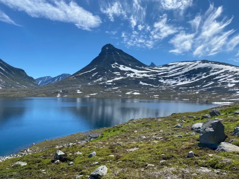
The segment across Murkløpphøgda unfolds as an exhilarating 10 km walk, offering breathtaking vistas of the Hurrungane peaks.
This terrain vividly showcases the construction of a road based on “the French principle.” It follows an unswervingly straight line, prioritizing drainage and foundational work over the natural characteristics of the landscape. In practical terms, it represented the most direct path from Gamlestøga on the eastern side to Maristova on the western side.
This distinctive road-building approach becomes particularly evident when walking from west to east, starting at Maristova and ascending the hills famously known as “the seven disappointments.”
Prepare for a challenging ascent – it’s steep.
The nomenclature of these hills stems from the recurring scenario where, upon thinking you’ve conquered the climb, another hill emerges before reaching the summit. This cycle repeats seven times, hence the name “the seven disappointments,” reflecting the periodic letdowns during the ascent.
Leg 6 – Maristova to Borlaug
| Time | Difficulty | Distance | Suitable for |
| 2 hours | Medium | 7 km | Everybody |
The Maristova to Borlaug stretch spans 7 km with an elevation gain of 300 meters, mostly featuring the original grassy track of Kongevegen.
Adjacent segments include the mountain stretch from Kyrkjestølen to Maristova and Borlaug to Borgund Stave Church.
Beginning at Maristova and heading west, you’ll immediately encounter impressive wooden bridges, all constructed according to the directives issued by the Director-General of Roads, J. C. Hammer, in 1794. These bridges were characteristic of Kongevegen upon its completion in the 1790s, and the route proceeds along straight, grassy stretches.
Consider a brief detour
For those inclined, a short detour around Honingane provides a glimpse of an old mountain dairy farm area with structures dating back to medieval times.
To continue, you’ll need to cross the E16. At Honingane, several bridges from at least four different routes can be found. The path you’re traversing is a gravel road dating back to 1860. The area’s name, “hone,” is an ancient term for goat.
Near one of the bridges, the mountain farm has been reconstructed and is available for breaks or overnight stays. A key is provided in a box on the wall, and for the code, please call +47 900 53 796 (Lærdal Municipality, Cultural Office). Bring a sleeping bag, as there’s no electricity in the cabin. Outdoor toilet facilities are available for both overnight guests and hikers.
Leg 7 – Borlaug – Borgund Stave Church
| Time | Difficulty | Distance | Suitable for |
| 2,5 hours | Easy | 13 km | Everybody |
This portion guides you through the picturesque village of Borgund, situated at the highest point in Lærdal.
The segment lies between the Maristova–Borlaug and Vindhellavegen stretches.
The majority of the path is paved.
For those heading west towards Lærdalsøyri, your journey begins at the junction of HI Borlaug Vandrarheim and Borlo Farmyard on both sides of the road. Commence from the farmyard car park, following the signs on the left of the “petrol man.” Ascend past meticulously restored storehouses and trace the original Kongevegen route from the yard, descending through the outfields.
Alternatively, if you are trekking along Kongevegen and have concluded the Maristova–Borlaug section, continue through the yard and trail the Kongevegen route down the outfields, now demarcated by a stone wall.
After a short distance, you’ll need to cross a fence and proceed along the E16 (mostly behind a low mound) for approximately 500 meters until you reach the junction with the turn-off leading to the center of Borgund.
At the junction, follow the county road towards the center of Borgund.
Leg 8 – Vindhellavegen
| Time | Difficulty | Distance | Suitable for |
| 1 hour | Medium | 1,7 km | Everybody |
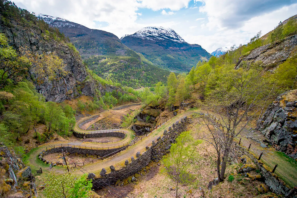
In truth, Vindhellavegen began as an unsuccessful road project, yet its fame arose from the steep, narrow bends supported by high foundation walls.
This segment faithfully follows the entirety of the original Kongevegen. If your journey takes you west towards Lærdalsøyri, the route commences 300 meters east of Borgund Stave Church. Alternatively, begin your walk at the stave church, proceed behind the new red church, and ascend the hills following the signs.
The culmination of this section is at Rimskjold, where parking and toilet facilities can be found (behind the corner of the youth club).
Rimskjold and the church area both serve as starting points for the Vindhella–Sverrestigen round-trip.
Ascent of the heights
The narrow Vindhella pass above Borgund Stave Church has long been traversed by travelers between the east and west. Initially, it functioned as a bridle and packhorse track through perilous terrains, eventually evolving into a postal route. It wasn’t until the 1790s, with the advent of Kongevegen, that the road attained the standard we see today.
However, Kongevegen presented its challenges, with a steep gradient of 1:4, posing difficulties for horse-drawn carts, especially in winter. Recognizing the need for improvement in the 1840s, road authorities undertook the construction of a new horse-and-cart road through the pass, elevated on high foundation walls, introducing new bends to mitigate the gradient.
While these endeavors didn’t significantly improve the gradient, reducing it only to 1:5, the roads through Vindhellaskaret were, from a gradient perspective, two unsuccessful projects. Yet, the broader perspective reveals the engineering mastery of both Kongevegen from the 1790s and its 1840s replacement, Bergenske Hovedvej. These roads showcased spectacular design with high foundation walls, now recognized as Norway’s most beautiful road-related cultural heritage.
Kongevegen has received the Beautiful Roads Award (Vakre Vegars Pris) and the prestigious Europa Nostra Cultural Heritage Award from the EU, with Vindhellavegen playing a crucial role in this acknowledgment.
Leg 9 – Øygardsvegen

| Time | Difficulty | Distance | Suitable for |
| 1 hour | Medium | 2,6 km | Everybody |
Øygardsvegen connects the renowned routes of Galdane and Vindhellavegen, showcasing its own unique beauty that should not be overlooked.
While Øygardsvegen may not boast the grandeur of Vindhella and Seltunsåsen, it holds its own charm as it winds across cliffs and knolls. Notably, the modern E16 tunnel, Borgundstunnelen, runs just below, with trucks zipping through as you walk along the 200-year-old Kongevegen.
This route also passes by ancient bridges, farms, coaching inns, and Iron Age burial sites, contributing to the rich cultural landscape.
Traces of the past
Heading west, you’ll return to where you finished Vindhellavegen. Starting from the Rimskjold car park, follow the old E16 for about a kilometer on tarmac, passing the historic coaching inn, Husum.
Before reaching the bridge, make a left turn onto the original Kongevegen. Prior to that, take a brief detour (30 meters) to the old Nedre Kvame bridge. This beautiful vaulted stone bridge from 1863 replaced the Steine bridge, swept away during the 1860 flood.
The Øygardsvegen section you’re about to explore was in use until the construction of this bridge in 1863. Further down, on the left side of the river, you’ll spot Nedre Kvame farm, with a large field to the right featuring an Iron Age burial site.
While some graves have vanished due to road construction in 1863, several burial mounds still remain, interspersed among grazing animals.
Leg 10 – Galdane

| Time | Difficulty | Distance | Suitable for |
| 2 – 4 hours | Easy | 4 km | Everybody |
The Kongevegen route through Galdane is rich with tales and sights that have influenced national symbols.
Notable landmarks like the storied Olavsklemma, the grand Laukebergbakken, the scenic Soknefossen, and the intriguing Galdane croft are just a few highlights of this area.
Galdane encompasses the section from Øygardsvegen going west, and Selto–Ljøsne heading east.
Starting the journey westward begins at Sjurhaugen, where you’ll find parking and toilet facilities.
Hazardous path
The passage through Galdane quickly gained a reputation as one of the most challenging and perilous segments across Filefjell. In its confined valley, marked by steep, rocky landscapes, there’s barely enough space for both the river and the road.
During icy conditions, the area became particularly hazardous. The risks escalated with melting ice, heightening the threat of avalanches and rockslides.
As you head west from Sjurhaugen, one of the initial attractions you’ll come across is Olavsklemma.
Leg 11 – Selto – Ljøsne
| Time | Difficulty | Distance | Suitable for |
| 2 hours | Easy | 8 – 10 km | Everybody |
Encounter authentic trolls, artificially irrigated cultural landscapes, and remnants of a Viking village along the path between Selto and Ljøsne.
This stretch includes Galdane if you’re going west, and Lærdalsøyri–Ljøsne if you’re heading east.
The majority of this route is paved.
However, there’s an exceptional 2 km stretch through an extraordinary cultural landscape situated midway through this section.
When traveling west, begin at Selto, the endpoint of your Galdane journey. From Selto, cross the E16 and proceed on a paved footpath that runs along Lærdalselvi and past Bjørkum.
Leg 12 – Ljøsne – Lærdalsøyri
| Time | Difficulty | Distance | Suitable for |
| 2 – 2,5 hours | Easy | 9 – 12 km | Everybody |
The entire stretch between Lærdalsøyri and Ljøsne is paved. Much of what was once the original Kongevegen is now beneath the current E16 and route 5.
The journey along Kongevegen begins at the harbor in Gamle Lærdalsøyri, the old section of Lærdalsøyri. It proceeds along the main street, which is part of the original pathway, heading towards the hospital and continuing on route 271 to the Voll bridge. Directions are available near Voll bridge. From there, take route 272 to Ljøsne.
For additional guidance, refer to the “Where to walk” section and use the map, following signage along the way.
Historical significance
In Lærdalsøyri, the historical impact of Kongevegen is evident, as it facilitated the growth of a small town near the fjord.
Lærdal has historically been a confluence for traders from Valdres, Hallingdal, Sogn, and the northern Gudbrandsdalen. Coastal inhabitants would bring fish and salt from the sea, while those from the eastern regions traversed the mountains to trade hides and meat.
This trading activity suggests the longstanding presence of a seaport where the Lærdalsfjorden meets the land.