Hiking Routes in Jotunheimen National Park
About hiking in Jotunheimen
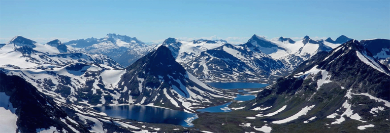
If you are comfortable above 2000 metres, there are 253 possibilities in Jotunheimen. Here you will find Norway’s highest mountain, some of Norway’s most popular mountain tours , emerald green Gjende lake, and great accommodation for the perfect holiday in the mountains.
It was the poet Aasmund Olavsson Vinje who first used the name Jotunheimen. He walked a lot in the area in the 1860s and had a cottage near Bygdin in Valdres. The word “jotun” means giant, and Jotunheimen was the name of the place where the jotnes – trolls – lived in Norse mythology.
Where is Jotunheimen national park

When to hike in Jotunheimen
The best time of year for hiking in Jotunheimen is from the middle of July until the middle of August. June and September or even early October may also offer pleasant hiking conditions, depending on weather conditions and the amount of snow.
Winter in Jotunheimen national park
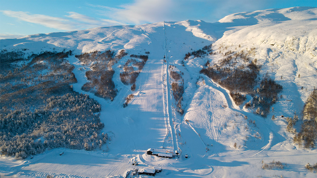
In winter, Jotunheimen is a top-class ski area. There are also very good cross-country skiing opportunities. Here you can actually strap on your skis down in the valley and walk up groomed cross-country tracks past Lemonsjøen, through Sjodalen, and right into the heart of Jotunheimen near Gjende. And with great restaurants and accommodation options along the way.
On Lake Lemonsjøen there is also the country’s most charming alpine resort, which has fostered some of the world’s roughest skiers. Many Norwegians make pilgrimages to Jotunheimen and Sjodalen when the spring skiing season approaches, and with a stable climate and stable conditions, Jotunheimen has become one of the most popular areas in the country for randonnée and summit ski tours.
You can find more info on lemonsjo-alpinsenter.no
Summer in Jotunheimen national park
Jotunheimen has an extensive trail network, and one that is well organized for hiking trips, whether it is short family-friendly hikes, high mountain hikes and summit hikes with glacier walking and climbing, or several day hut-to-hut hikes.

In summer months Jotunheimen abounds with opportunities for fishing and hunting for small and large game. The restaurants in the area often source the ingredients straight from nature’s own treasure trove. In the streams and fishing waters, the trout bite willingly, in autumn you can pick berries and mushrooms, and reindeer, moose, and grouse thrive in the mountain landscape.
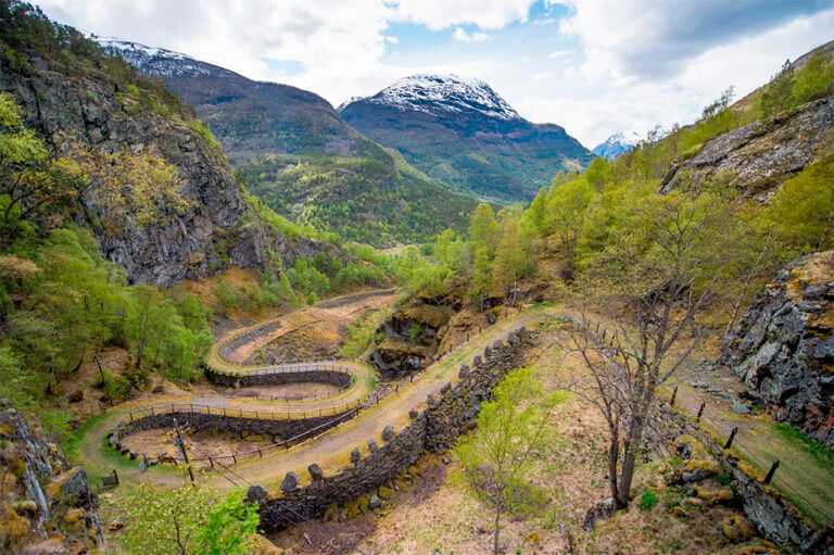
THE ROAD OVER VALDRESFLYE
The road swoops and stretches out ahead in long sweeps of undulating terrain.
A drive with a panoramic view of the mountains and wide expanses at the gateway to Jotunheimen, through cultural landscapes with mountain dairy farms and traditional tourist enterprises.
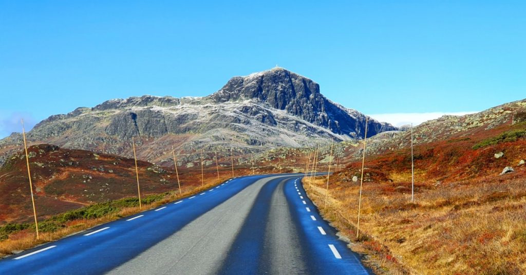
Up on Valdresflye you get the feeling of “hovering” above the mountain plateau with a great view towards many of the mountain peaks of Jotunheimen National Park. Large parts of the route runs above the tree line, with the highest point at 1389 meters above sea level.
Valdresflye is like a large painting where the road swoops and stretches out ahead in long sweeps of undulating terrain. The route forms part of a number of circular drives, and is an alternative if you are heading north.
Valdresflye is closed in winter, usually from Christmas to Easter. But the road through Sjodalen to Gjende and Gjendesheim is plowed all winter and it is possible to drive to Gjende, via Vågå/Heidal, all year round.
Jotunheimen National Park Trails
When hiking in Jotunheimen National Park, you will have thousands of kilometres of walks, covering all kinds of magnificent terrain, to choose from. Walk for for half an hour, a day, a week or a month! Choose the track that suits your ability and schedule.
Jotunheimen is one of Norway’s most rocky areas with sharp peaks and deep valleys. The dramatic landscape is made up of snow, ice, rocks and vegetation. In the Jotunheimen National Park you will find one of Norway’s most popular and stunning hikes, the narrow Besseggen ridge that runs between a green and a blue lake. Norway’s national park offers Northern Europe’s most beautiful vistas and dramatic walks. If Jotunheimen is the heart of Norway, thousands of kilometres of tracks are its veins. Are you ready?!
Walking in Jotunheimen can be everything from a short one-day hike to a multiple-day trek. From the Bygdin Lake in the East, discover the stunning summit of Synshorn (1,475 m.a.s.l.). Or a nice and short trip with beautiful views over Jotunheimen, Raslet, Kalvåhøgde, Heimdalen and Østre Slidre. Try also the longer hike to Bitihorn (1607 m.a.s.l.), that lies at the entrance to Jotunheimen National Park. Get on the boat M/B Bitihorn and travel across the Bygdin Lake to Torfinnsbu to hike the mysterious Svartdalen Valley. Attempt a climb up the impressive peaks of Torfinnstraversen or Nørdre Kalvehøtinden. Here you will be accompanied by local guides as the ascents require skill, climbing and special equipment.
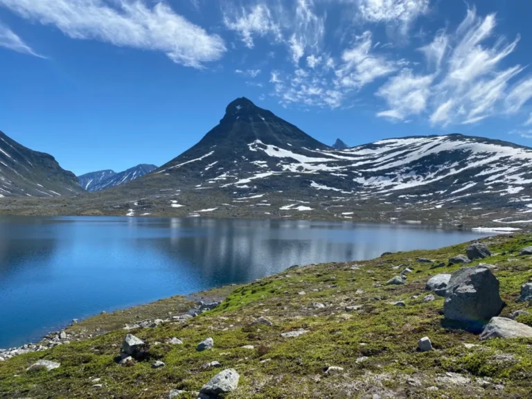
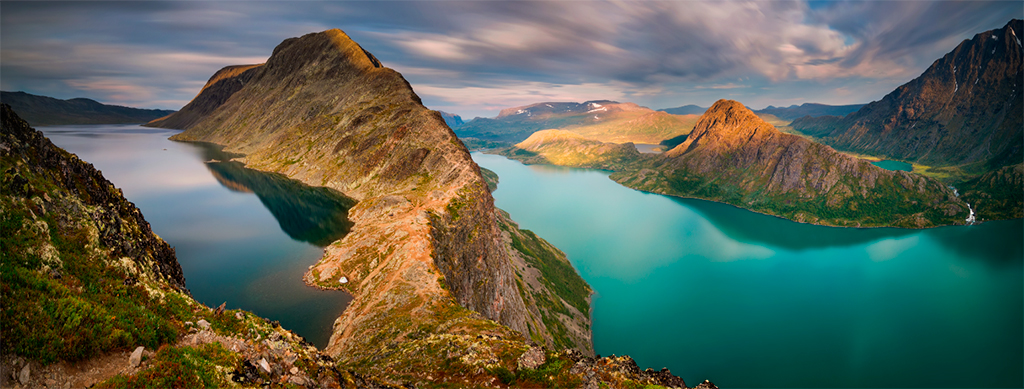
North of the Bygdin Lake lies the emerald green Gjende Lake, surrounded by Veslefjellet, Besseggen, Memurutunga, Bukkelægret, Gjendtunga and so much more. These hikes can be enjoyed individually where you can board the boat Gjendebåten. Or you can combine them on a multi-day hike and experience the trekking of a life time. West for Bygdin Lake you will find Eidsbugarden, and access to a range of hikes, including short family friendly trips to Utsikten or Torshamaren, and glacier walks to Uranostind.
Maps of the Jotunheimen National Park trails can be obtained in local stores, hotels and tourist information offices as well as online or in upscale bookshops across Europe and the rest of the world.
Hiking possibilities in Jotunheimen
There are more than 50 marked routes within the national park and about a further 70 in the surrounding areas. The duration of the hikes vary from one hour up to eight or ten hours. There are also plenty of opportunities for multi-day hikes, lasting from three to ten days or even longer. For hikes to the higher areas of the Jotunheimen National Park, an average physical condition is recommended and previous experience is definitely a benefit. Families and non-experienced hikers may prefer one of the flat, easy routes in the valleys. There are also short, easy hikes outside the park, for example in Beitotstølen, Lom or in the Skjåk municipality.
Jotunheimen is incredibly popular amongst hikers and climbers, in particular the famous Besseggen-trail, and the Norwegian Mountain Touring Association (DNT) maintains a number mountain lodges in the area, as well as well-marked trails that run between the lodges and others up to some of the peaks.
Historic Hiking Route
The route goes from the Gjende Lake in the East to Bygdin Lake in the West; starting from Gjendesheim you will hike the popular Besseggen trail over to Memurubu, a classic adventure for Norwegians. Over the years more and more tourists have been drawn to take the journey across this mountain ridge, in the footsteps of great adventurers. In recent years, an estimate of around 60 000 hikers cross this popular ride annually.
Jotunheimen takes you on the best Norwegian mountain country has to offer. It follows in the historical footsteps of famous Norwegians, including Peer Gynt, Jo Gjende, Edvard Grieg and Edvard Munch.
You find more information on jotunheimen.com/products/historical-route-jotunheimen
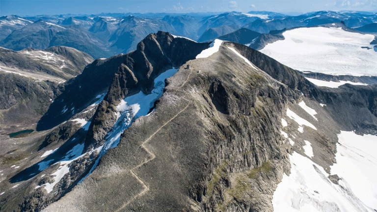
Galdhopiggen Trail
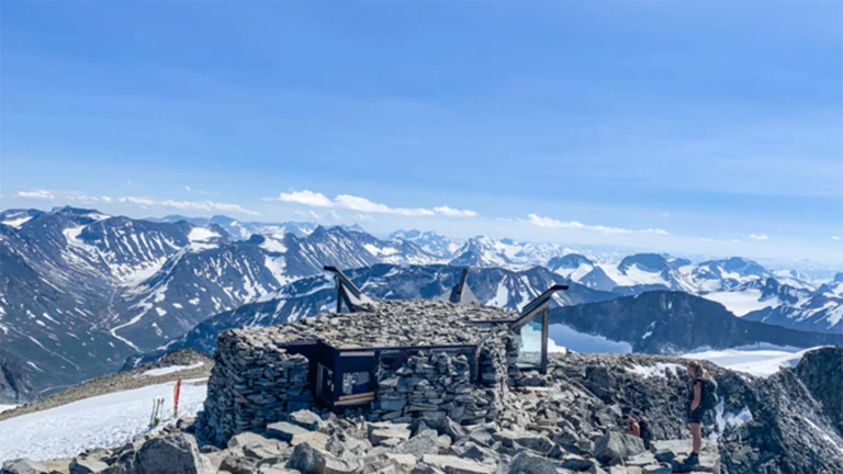
Juvasshytta lies 1840 m.a.s.l., and is a natural starting point for trips to Norway’s highest mountain. For safety reasons, participants on these tours walk on a rope. In the summer season there are daily guided tours to the top.
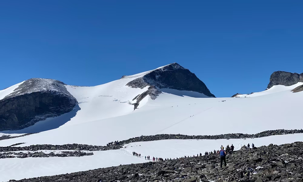
The trip from Juvasshytta to the top of Galdhøpiggen is about 5 km long – with an increase of 650 vertical meters. The trip is about 12 km. long and takes normally 5-7 hours (round trip from Juvasshytta).
Season:
High season from the beginning of June to the Middle of September. (Contact Juvasshytta for trips before June 1st)
Gjendesheimen to Lake Bessvatnet
Surrounded by majestic Jotunheimen mountains and situated by the scenic lake Gjende at 1000 metres above sea level, Gjendesheim is the most visited mountain lodge north of the Alps.
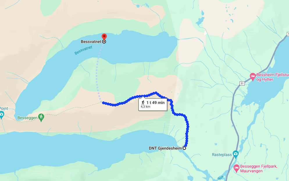
Bessvatnet is a lake located in Vågå municipality in Innlandet. Bessvatnet is well known to everyone who has walked Besseggen, as you have the blue Bessvatnet on one side of the egg and the green Gjende on the other side. The mountain Besshøe is located right by Lake Bessvatnet.
Please visit official DNT site for Gjendesheim for more info.
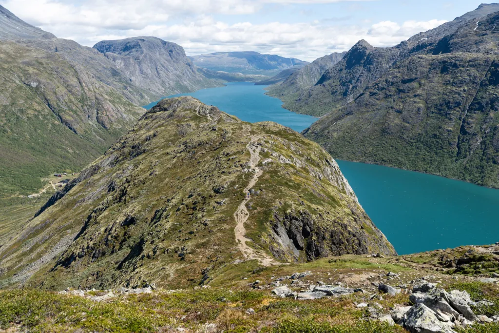
Besseggen (Memurubu ↔ Gjendesheim)
The trip over Besseggen between Memurubu and Gjendesheim is one of Norway’s most popular mountain trips.
From Besseggen there is a fantastic view over the green-coloured Gjende and the blue-coloured Bessvatnet. The spectacular green color is the result of glacial water from the glaciers in the area, and on the trip over the mountain you will have plenty of opportunity to see both waters and be mesmerized by the fantastic view. Perhaps you also meet reindeer?
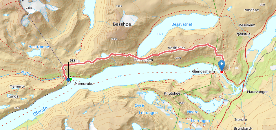
The trip can be made from Memurubu to Gjendesheim and vice versa. The most common is probably this route, but it is often said that the opposite route (from Gjendesheim to Memurubu) is for the tough. No matter which way you go, you get a fantastic view.
The Besseggen is a route that most people choose to walk slowly – both because it is steep and because you have a lot to rest your eyes on. The trip can in principle be taken all year round, but the vast majority do it in the summer. If it is a normal snowy winter, there is no snow on Besseggen from mid-June to the beginning of October.

Most people who take the trip over the narrow Besseggen ridge atake the boat into Gjende before embarking on the popular mountain tour. The Gjendebåt leaves from the pier at Gjendesheim every morning and takes you on to Memurubu. It is at Memurubu that the trip over Besseggen starts. You can also go Besseggen the other way. Then you start the trip from Gjendesheim or Bessheim. If you choose to go this way, you go down Besseggen and end up in Memurubu where you take the boat back to Gjendesheim.
Bukkelægret: Memurubu ↔ Gjendebu
Bukkelægret is the spectacular ascent from Gjende, on the route between the tourist huts Gjendebu and Memurubu.
- Total length: 9.5 kilometers.
- Ascent: Approx. 500 meters in altitude towards Memurutunga
- Time taken: 4.5 hours.

If you have walked Besseggen and are looking for a new walk along Gjende, Bukkelægret is highly recommended. Bukkelægret is the route that starts in the heart of Gjende, and runs along a well-marked path towards Memurubu.
The trip starts with the morning boat from Gjendesheim to Gjendebu. From the jetty, a marked path runs along the lake, which quickly begins to rise. Bukkelægret itself is a climb of 450 meters – from Lake Gjendevatnet. After walking the Bukkelægret itself, you come up to a path fork on a plateau, and walk in open and hilly terrain down towards Memurutunga. You follow this all the way down to Memurubu, and can enjoy the sight of emerald green Gjende all the way.
Chains have been laid out on the steepest parts, which are good for holding on to on the way up. The trip is known for its magnificent view over the west end of Gjende, and its rich mountain flora.
Glitterheim hut to Spitterstulen Mountain Lodge
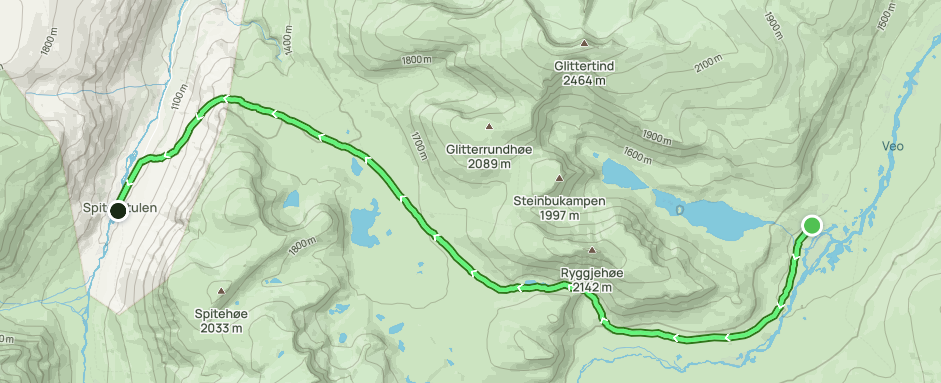
Hikers in Jotunheimen have a couple of options to get from Glitterheim to Spiterstulen. You can choose to go via Glittertind (advanced) or via Skautflye.
Leirvassbu hut to Gjendebu hut

Up Storådalen past the path section to Memurubu. Semmelåe wader or stone goose. Past Hellertjønne and up to the path section to Spiterstulen. Further along the east side of Langvatnet. Urdadøla stone goose or wading in the ooze. To the part of the path to Olavsbu and further past Lower and Upper Høgvagltjønnen and through Ur up to Høgvaglen. From here down into Gravdalen and past the path section to Skogadalsbøen and to Leirvassbu.
This is a demanding hike of 18.9 km estimated to take 7 hours. On the way, you will pass magnificent valleys and lakes. Hikers can expect to be surrounded by mountain peaks making them feel right in the home of the giants and trolls.
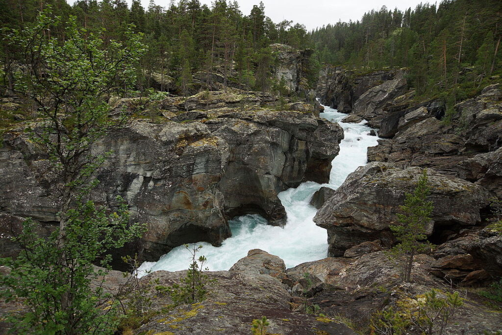
Ridderspranget (The Knight’s leap)
Ridderspranget is a narrow gorge in Sjodalen in Vågå where the river Sjoa cascades down.
According to folk memory collector Ivar Kleiven, the legend tells that the knight Sigvat on Kvie in Valdres had stolen a beautiful girl, called Skårvangsolen, from the knight Ivar Gjesling on Sandbu in Vågå. Sigvat set Skårvangsolen on his horse and rode off. Ivar set off after Sigvat and reached him again at Ridderspranget. But the horse with Sigvat and Skårvangsolen on top jumped over the gorge with the gushing water below. From there he prevented Ivar and his men from trying to make the jump after.
Please see location on Google Earth
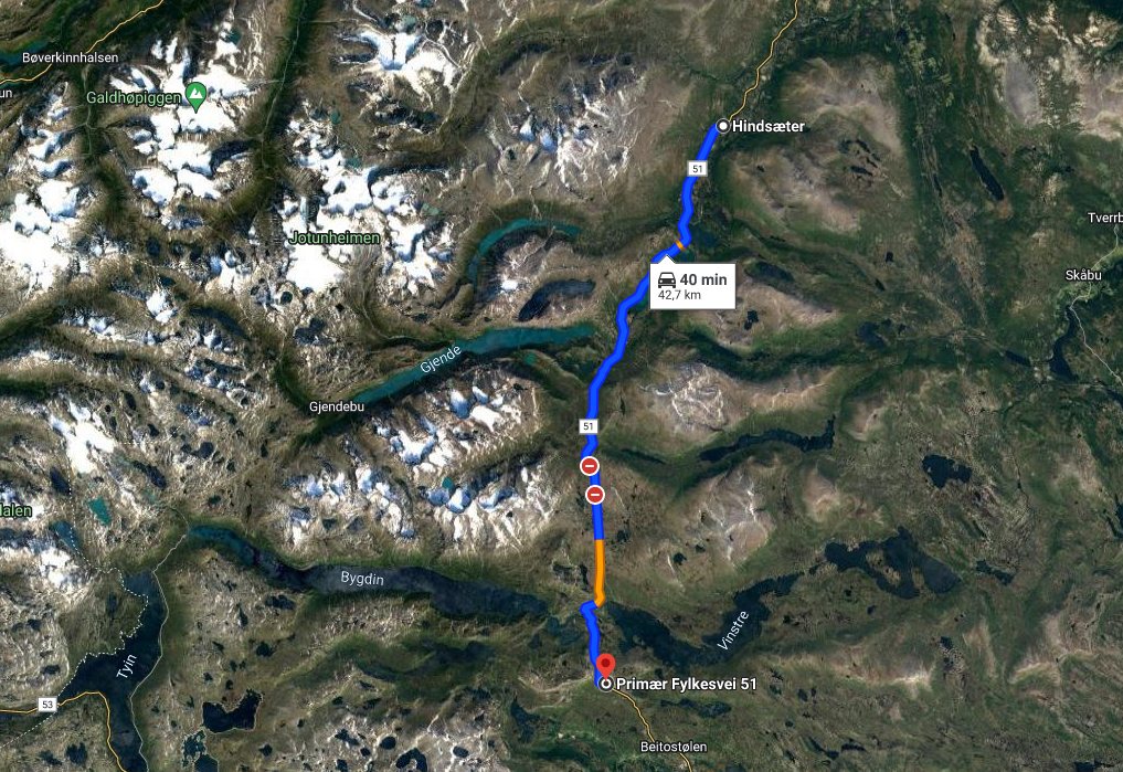
It is located in Sjodalen along route 51 only 30 minutes by car from DNT Gjendesheim.
Gjendetunga (From Gjendebu)
The round trip to Gjendetunga is a fantastic trip that gives a view of Gjende and all the beautiful peaks around.
This is a medium demanding trip with distance 12,8km expected to take about 5 hours. Best time to make the trip is from June to September.

If you live in Gjendebu, all you have to do is lace up your shoes and start your trip.
The tour starts by going west up the Veslådalen. Veslådalen is an easy-going and smooth downhill in the direction of Olavsbu – DNT’s self-service cabin. But not going that far today. Eventually you turn off the T-marked path and go east along Grisletjønnen (1,362 m). The hike is on steep terrain, so take plenty of breaks and drink plenty of water on the way up.

Finally, we end up at Gjendetunga, where you get a view of Gjende and all the world’s most beautiful valleys and peaks. This is truly a gem in Jotunheimen.
The walk down goes steeply downhill, but there is a clear path that is often followed by guests at Gjendebu.
The King’s Road
The Kings Road (Kongeveien) starts at Valdres and goes on to Lærdal.
Please also see separate post about The Kings Road
The award-winning Kongevegen over Filefjell was built in the 1790s and was the first carriage road (horse and cart) between East and West Norway and Christiania-Bergen. The road replaced the bridle and fork road from the Iron Age, the single track road from the Middle Ages and the post road from the 17th century.
Viking chieftains, medieval kings and officials of the Danish king. All had one thing in common as they traveled between east and west; they had to walk over Filefjell. Are we as good as our ancestors? Walk Kongevegen all the way, from Valdres to Lærdal!
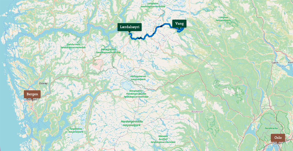
The 100 km long hiking route Kongevegen over Filefjell takes you through some of the most beautiful landscapes in Norway. From the inland villages of Valdres via the high mountain on Filefjell and down to the narrow and dramatic fjord landscape in the innermost part of the Sognefjord. Kongevegen over Filefjell has won the prestigious Europa Nostra Grand Prix (2017) and Vakre Vegars Pris (2015). In February 2022, arrangements were also made to ski parts of the Kongevegen over Filefjell.